Welcome to the AvPlan EFB for Android’s Ultra-Quick Guide. This is designed for users that have experience with a touchscreen environment, and/or experience using another EFB product. It is not designed to replace the full User Manual.
| Downloading required documents |
- Tap Settings > Data Downloads. Tap on the region(s) you wish to fly in and select Download. To view the download progress, bring down the notification shade. The area(s) will turn green when the basic required documents (maps and taxi diagrams/approach plates etc) are downloaded.
|
|
| Begin a New Flight Plan |
Either:
- Tap the
![New Plan]() button at top of Flight Plan Index list. button at top of Flight Plan Index list.
or
- Tap the EnRoute map to bring up the Nearest Items list. Tap the New Plan button at the bottom of the Nearest Items list.
|
| |
| Select a different aircraft/callsign |
- Tap the select callsign option at the bottom of the flight log.
![]()
- If your aircraft’s callsign is not yet in the list, you can create it by tapping Settings > Aircraft Type Database.
|
| |
| Add waypoints to your plan |
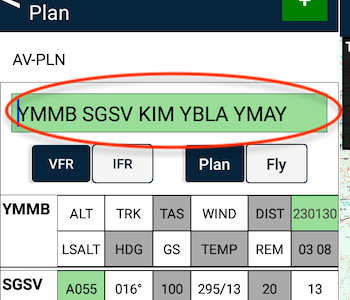
- Via the Quick Plan Entry field.
![Quick Plan Entry field]()
or
- Via the Nearest Items dialogue on the EnRoute tab.
- Tap the
![]() to the right of your desired waypoint to quickly add it to your plan. to the right of your desired waypoint to quickly add it to your plan.
- If you tap on the row of the waypoint, rather than the quick add icon, select Insert from the Waypoint Details menu.
- NOTE: Essentials subscribers will need to use this method.
or
- Via ‘rubber banding’ the track line, if you already have two or more waypoints in your plan. Press and hold on the red track line until a blue halo appears around your finger:
![]()
- Tap the
![]() to the right of your desired waypoint to quickly add it to your plan. to the right of your desired waypoint to quickly add it to your plan.
|
| |
| Single-tap the EnRoute map |
- Brings up the Nearest Items list. This list is a search for ground-based places/features around where you tapped. These include; airports/Heliports, Navaids, Waypoints, etc.
|
| |
| Double-tap the EnRoute map |
- Brings up a list of airspace-related items. For example; prohibited areas, danger areas, NOTAMed airspace, etc. Tap on one within the list to
- see it highlighted on the map, and/or
- read any NOTAM information, etc (if applicable)
|
| |
| Going Flying |
- Open/Create a flight plan.
- Tap the Plan/Fly switch at the top of the flight log to switch to Fly mode.
- Tap the DEPARTURE button at the top of the EnRoute tab to log your departure time and set your flight plan in motion.
|
| |
| Accessing Airport Details/Documents |
- Tap the airport’s row in the flight log to open the Terminal tab to that place
or
- Tap the red waypoint dot on the EnRoute map’s flight route to bring up the Waypoint Details menu
or
- Tap the EnRoute map near your place to bring up the Nearest Items list. Tap the place in the list to bring up the Waypoint Details menu.
|
| |
| Close Flight Plan |
- Tap the Close Plan button at top of flight plan
![]()
or
- Tap the EnRoute map to bring up the Nearest Items list. Tap the Close Plan button at the bottom of the Nearest Items list.
|


 button at top of

