The status of Special Use Airspace (Prohibited/Restricted/Danger/Military) can be displayed on top of all maps. Place a tick next to Active Airspace to make them visible.
Active Airspace colour key:
| Red | Airspace is active now, or the NOTAM is too convoluted for the system to extract status reliably. AvPlan errs on the side of caution and a ‘Check’ status is applied. |
|---|---|
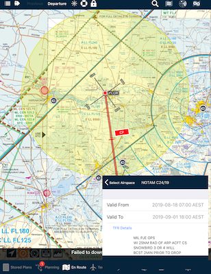
| Yellow | Airspace will become active in the future (at which time it will turn red). |
| Grey | AvPlan EFB has been unable to obtain an update in order to determine active or de-active status. Make sure your 4G data is on, or connect to a WiFi hot spot or check your NAIPS login status in order to download updates. |
- Double-tap the map to display all airspace information above that point.
- The lower and upper limits of each airspace is displayed in the right-hand column of a list item.
 Select airspace
- All controlled airspace will be listed.
- The QNH Forecast region will be listed. Tap the > symbol in that line to request an updated QNH for that region. This procedure works even if that region does not appear in your flight plan – or even if you do not have a flight plan open.
- The FIA and frequency can be found here.
- Any Prohibited, Restricted, Danger or Militarty (PRDM) areas
- Tap an entry in this list to access information (where available – e.g. QNH) and also highlight the boundaries on the map for ten seconds. PRDM areas will show Planning status (RA1 or RA2; there are no RA3’s at present) and a direct link to relevant ERSA page where the PRDM will be highlighted in blue.
NOTAM Airspace
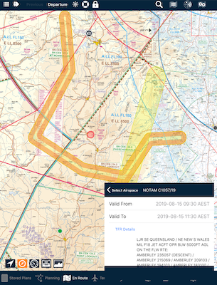
From time-to-time, special airspace areas will appear on the map. These are also known as Temporary Restricted Airspace areas (TRA)s.
In Australia, one example is the Low Jet Route (LJR). These are routes flown by RAAF fast jet aircraft below 5000’ AGL. AvPlan’s systems will decipher the NOTAM and display the route on the map.
 Upcoming Low Jet Route (LJR) example Upcoming Low Jet Route (LJR) example |
 Active Low Jet Route example Active Low Jet Route example |
 Upcoming NOTAM airspace example
Need more help with this?
Help Centre (Tap and hold to open the Link)


